Last Update: 31st December 2020
This is the Documents page for the Horspath Archaeology & History Group.
The following documents are in PDF format (unless otherwise noted) and can be downloaded by clicking on the associated link.
Note that the Newsletters that used to be listed on this page have been moved to their own page, "Newsletters".
Wheatley Roman Villa Notes
Chris has put together a short document describing the Roman Villa in Wheatley and the Anglo-Saxon cemetery found nearby. We hope to expand on this document in the future.
Download (2.1 MB): Wheatley Roman Villa Notes (pdf)
MPRD Project Flyer
For our latest project, documenting the Metal Products Recovery Depot (MPRD), we have created a 2-page flyer which will be handed out in the HUB in Horspath to spread the word.
Download (6.1 MB): MPRD Hub Flyer (pdf)
The Lost Village of Old Horsepath
This document is an updated version of the summary of investigations into the "lost" medieval village of
Old Horsepath which Chris and Sally distributed in 2018.
With additional notes on a "lost" watermill at Cuddesdon and important input from Ivan Wright on an ancient track
from Headington to Horspath, which may just turn out to be a branch of the main Roman Road through East Oxfordshire.
The current document is a draft dated December 2020. Revised editions of this document will be posted here.
Download (11.7 MB): Lost Village of Old Horsepath (pdf)
Horspath Field Names
This is a document recording the field names within and around Horspath. Put together by Chris from various sources.
Download (60 KB): Horspath Field Names (pdf)
Oxford Archaeological Resource
Oxford Archaeological Resource Assessment 2011, "The Modern Period (1800-1950)", Compiled by Ruth Beckley and David Radford, Version: 28/1/2012
This report summarises the available archaeological evidence for the Modern Period (1800-1950) from the Oxford City Council Local Authority Area and forms part of the resource assessment stage of the Oxford Archaeological Plan. The aim of the report is to aid heritage asset management and inform field investigation and academic research.
Download (1.3 MB): Oxford Archaeological Resource (pdf)
"Browse" Section
The full text of some of the above pdf documents are shown below to allow people to browse the content before downloading the pdf file.
- - - - - - - - - - - -
Wheatley Villa Bath House.
These notes were assembled by Chris, mainly from an original article by William Bromet on the excavations, written up in the Archaeological Journal of 1845. See:
"Bromet, W., (1845). Notice of a Roman Villa at Wheatley, near Oxford. The Archaeological Journal 2. Vol 2, pp. 350-356".
Notice of a Roman Villa pdf link
Chris points out however that the 1854 excavations detailed here were only on the bath-house. The main villa itself was not found at that time.
Press reports some years later quoted the then farmer as saying he had ploughed up the entire site - presumably to deter hoards of visiting academics from the university. However, ploughing up the stone foundations of a substantial villa simply would not have been possible with horse-drawn equipment!
So Chris and Geoff persevered and by careful use of advanced graphics software, played around with tones and shading on a Google Earth capture, managed to reveal what appears to be the crop-mark outline of that main villa, slightly above and to the left of the bath-house . (The Google Earth cover has been redacted from this report to protect the farmer's land from illegal detectorists.)
With the permission of a very friendly farmer (whose truly magnificent herd of South Devon cattle made the visit worthwhile in its own right!) we visited the site in 2019, but there was nothing at all to be seen at ground level.
Given the size (and importance) of the villa in Roman times and its probably extensive land holdings, it is likely that some, if not all, of the present Horspath fields were once a part of that estate.
Apropos of which, Simon and Toby Shew from Wheatley have done a wonderful job of metal detecting many of our fields (with Denis Walker's permission) and we look forward to an analysis of the multitude of Roman coins they've found - once the Portable Antiquities Scheme has worked its way through their vast backlogs and have processed them!
Chris also reports that he has found 3rd century greyware potsherds on the Horspath Allotments (along the Cuddesdon Road), and two Roman coins of Constantine the Great (AD 306 to 337) just inside the present entrance of the allotments. Good evidence that these fields were in use at that time as we know that villa middens - kitchen waste, including broken pottery, and animal dung - would have been spread on the arable land to improve fertility. Chris also found further small deposits of Roman greyware pottery alongside a ditch near the City Sports Field.
What follows is the original 1845 excavation report:
Part of a house {just the bath-house! cjp} covering an area at least 190 ft. from north to south (the plan below only shows a dimension of about 45 by 20ft. Perhaps the 190ft mentioned was the total area excavated? Cjp) was opened by a very distinguished company - J. H. Parker, the Bishop of Oxford (Dr. Stubbs), and Dr. Buckland, the geologist, then Dean of Westminster - about 1845, on Castle Hill, south of the village and SW. of New Barn. The site is a typical one on high ground sloping south and east to the River Thame.
The most important discovery was part of a bath-building, the plan of which is here shown (Fig. 39). What looks like the frigidarium (g), measuring 8 ft. by 4 ft., is at the east end, with a waste-pipe (of two concave tiles one within the other, fig. 2) in the middle of the east wall. To the west was the caldarium, 14 ft. by 12 ft., the floor supported on a pillared hypocaust, with a sudatorium (e) in the SW. corner, the east and west walls of which were jacketed with flue-tiles heated by means of two arched flues from the caldarium. A lead pipe pierces the centre of the southern wall at floor-level, emptying into what appears to be a drain running all along the south side. On the west another bath, about 10 ft. by 5 ft. (d), was found over a furnace-arch, and had raised shelves or benches or steps on each side. The stokehole (a), with benches (b) on each side for the stoker, lay to the west.
The external walls were about 2 ft. thick and of stone; the hypocaust and flues of brick. The walls were plastered and painted in patterns and there was a moulding at the junction of floor and wall. Unfortunately there are no details of the pottery, but the coins noted are of Maximinus, Salonina, Constantine, and Gratian.
Fragments of an Andernach millstone and another of red grit-stone were found. Though 'covered by a building adequate to guard them for a century,' by 1872 every stone of the villa (Bath House! cjp) had disappeared, the shed having been pulled down and the place deliberately ploughed about ten years previously. [Arch. Journ. ii, 350 ff.; iii, 92 (W. Buckland); hence Illustrated London News, viii, 248, 11 April 1846, and O.A. and H. Soc., n.s., iii, 4.]
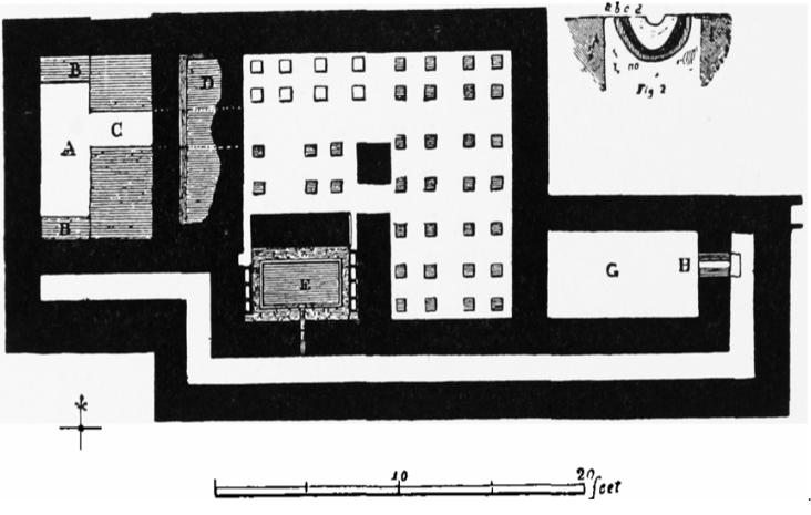
Bath House Plan
The following two reports are from the Victoria County History of England, Oxford, vol 5 (Bullingdon) and complete our current knowledge of that lovely valley overlooking the River Thame.
Cuddesdon
A house exists in a wood immediately north of the Bishop's Palace on the hill overlooking the Thame Valley and about 3/4 mile south of the house on Castle Hill, Wheatley.
Some of it was opened in 1916, and a slight excavation was carried out by the O.U.A.S. in 1921, but, owing to the trees, it was not possible to follow out walls or obtain a plan. A hypocaust was discovered and just sufficient to show that there was a house, probably of a simple type. No sign of any tessellated floors appeared, but there were bits of opus signinum and coloured wall plaster. Among the quantities of pottery were a few fragments of south Gaulish ware, including a stamp of the preFlavian potter of. ardaci, another of the Flavian c.silvi, and rough-cast ware of the same date; most of it, however, except for some late 2nd-century Samian ware, was of the 3rd and 4th centuries and included grey cooking-vessels and much of the local colour-coated ware with pattern in red on a white slip. The eight coins found were Æ 1 Pius (Cohen, 751), and Faustina II (Cohen, 169), Æ 2 Claudius II (Cohen, 321), Æ 2 and 3 of Constantine I and II (Cohen, 124 and 113), 'Constantinopolis' and 'Urbs Roma' types, Magnentius (Cohen, 68), Constantius II, and Valens.
Of the two brooches found one was an interesting early tinned crossbow type and the other an oval gilt one set with a coneshaped cornelian, an early 4th-century type; a knife complete with its bone handle was also found. It looks, therefore, as if the house existed in the 3rd and 4th centuries on a site occupied in the 1st century. [Haverfield and Manning MSS. in the Ashmolean Museum. J.R.S. xxi, 214]. The pottery, oval brooch, knife, and some of the coins are in the Ashmolean Museum. For a similar brooch cf. Gent. Mag. 1788, ii, p. 270, V.C.H. Suffolk, i, 321 and Kent, iii, 79, and Arch. Ael., Ser. 3, vii, 1911, 181. For possible roads connecting the house with the Dorchester-Alchester road see pp. 279, 280, f.; and it should be noted that the Saxon cemetery (p. 352) was found about 300 yds. South of the house.
Anglo-Saxon Cemetery
Three-quarters of a mile south-south-east of Wheatley, a village 7 miles along the London road through High Wycombe, on rising ground overlooking the valley of the Thame, is a field known as Castle Hill or Castle Field, at the eastern end of which a Roman villa was discovered in 1845. (fn. 16)
About the end of 1882 labourers engaged in removing stone that hindered ploughing operations lighted upon several graves from which they collected spear-heads, a shield-boss, and a bone comb, which were presented to the Ashmolean Museum by Mr. Henry Gale.
In January and February, 1883, 15 more graves were opened and their contents recorded by Mr. Gale; in April and May members of the Ashmolean staff excavated 19, and in October 1884 another 12, making 46 in all. Of these the majority were orientated to points of the compass between north and south, principally south, a westerly orientation being quite rare. No actual cases of cremation are recorded, but mention of fragments of urns is made in the diary of the excavations. It is not impossible that urns had been destroyed in agricultural operations, since even the graves, as usual in a limestone site, were for the most part shallow, averaging in depth 1 to 2 ft. at most. Some were even less; one 3 1/2 ft. deep was quite exceptional.
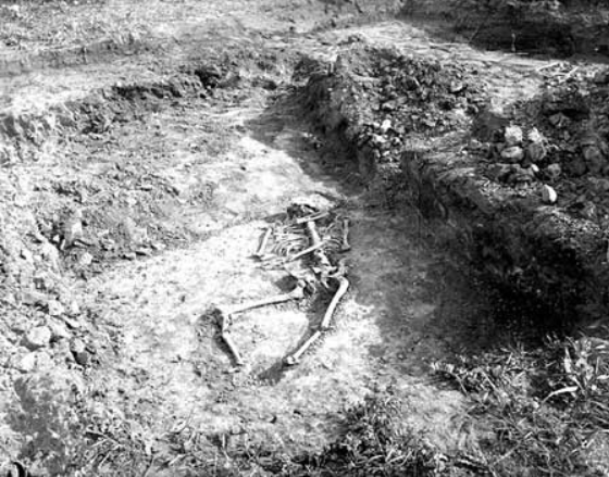
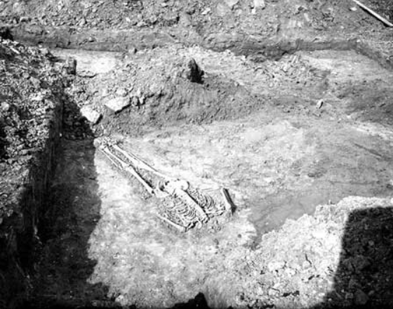
Below: photos of the excavation of the AS cemetery. (origin unknown)
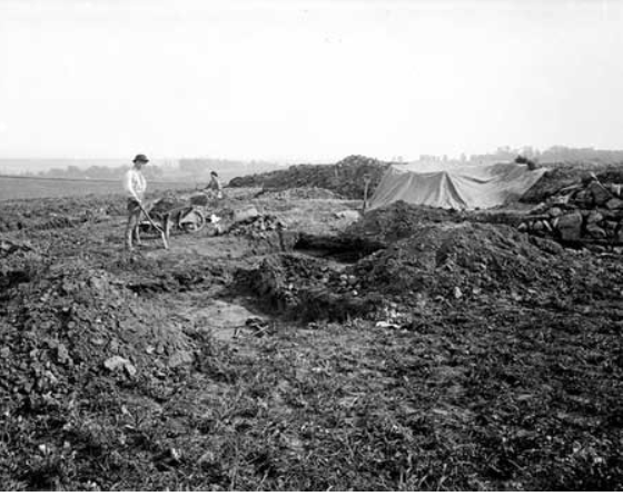
Anglo-Saxon Cemetery #1
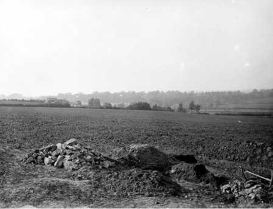
Anglo-Saxon Cemetery #2
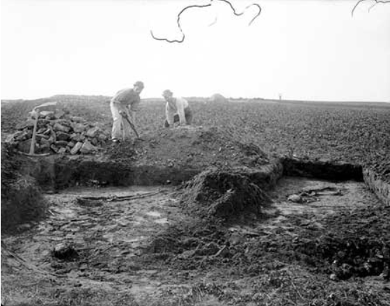
Anglo-Saxon Cemetery #3
Anglo-Saxon Cemetery #4
Anglo-Saxon Cemetery #5
The cemetery was not rich; many of the graves were devoid of relics, and apart from the weapons found in the first instance only two more spear-heads came to light. The two richest graves were nos. 27 and 14. (fn. 17) The former yielded a necklace of amber beads, from which depended three carnivore teeth and two 4th-century Roman coins, an earpick, and other objects, including a ring-headed Celtic pin of the Early Iron Age type.
In the latter (Pl. XXVI a) was a string of beads of amber, paste, and crystal, some of the amber specimens being of exceptionally large size. Matching these is a pair of huge gilt bronze saucer-brooches, over 3 ins. in diameter, in the decoration of which a medley of unintelligible zoomorphic ornament is combined with a flat central stud of garnet and three undecorated triangles, elements borrowed by the maker from the design of jewelled Kentish brooches.
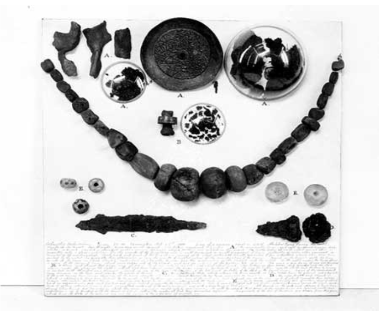
Anglo-Saxon Cemetery Finds
There were also a knife, an iron buckle with triangular plate, and, lastly, a silver pin with a discoid head decorated with an engraved rayed design around a central boss, and with a perforation a little below the head, through which is threaded a large ring of thin wire. Pins with ringed heads are cited by Baldwin Brown (fn. 18) from Anglo Saxon graves in Kent and at Brixworth, Northants., and, as he rightly observes, are 'Celtic rather than Germanic in character'. Many parallels can be found in Ireland. Two graves produced 4th-century Roman vases, possibly, like the ring-headed pin in grave 27, looted from the site of the Roman villa nearby.
End of article
Horspath Field Names
From Corpus Christi Estate map 1605 (mostly Bullingdon Green area)
Coll. Woode
Greate Chauley
The Greate Grounde
The Hill Ground
Horspathe Comon (sic)
Horspathe Fielde
Little Chauley
The Meadowe
Perriall Closes
From 1848 Tithe Award Map (see Digweed & Saunders compilation, att, for locations)
Acre Mead Hill
Bag Coppice
Blacklands
Breach Furlong
Bricklands Ground
Brook Furlong
Broad & Little Peterley
Brown's Bush Furlong
Bullingdon Green
Charleys
Coles Bush Furlong
Costard Furlong
(shooting on) Costard Furlong
Cow Common
The Common
(shootings on) The Common
Cuddesdon Path Furlong
(shootings on) Denton Field
Dicksey's Furlong
Ferney Furlong
Forty Furlong
(shootings on) Gateley Way
Gateley Way Common
Gateley Way Furlong
Golder Hill Furlong
Great Grot Mead
Great Peril
Grove Furlong
Harrow Ground
Hill Ground
Hockawell
Leys Furlong
The Linches
(shootings on) Little Grot Mead
Little Hill Ground
Little Peril
Long Fiveoaks
Long Westcombe
Longlands
Lower Charley
Mays Hill Meadow
The Meadow
Middle Furlong
Moor Furlong
Old Horspath
(shootings on) Old Horspath (X2)
Oxford Ground
Paddock Ground
Park Close
Platt's Sideland
Poplar Field
Revel Mead (NB: This is mis-spelt "Revet Mead" on the VCH Oxford Vol 5 map)
Sheep Hill Furlong
Short Hedge
Soanes Bottom
Stoney Furlong
Swillows Furlong
Upper Charley
Upper Common
Upper Furlong
Wheat Furlong
Winding Furlong
From 1855 Sale Poster in Westgate Local History Collection
(This land sale concerns the land around what is now Hill Farm and Old Horspath Farm. Both farmhouses were not built until a decade or so later. At the time of the sale there were two main fields relating to the old open field system of Old, or Upper Horspath, namely Upper Field and Lower Field. Lower, or Nether Horspath, now the only village, had its own open field system.)
The Breach
Broad Peterley
Brown's Bush
Cole's Bush Furlong
Cripp's Hill
Cuddesdon Path Furlong
Dicksey Furlong
Fearney Furlong
Five Oaks
Garsington Field
Golder Hill
Hollowbrook Furlong
Level Steep Hill
Little Peterley
Long Westcome
Long Shear
Lynches
Mays Hill
Mays Hill Bottom
Middle Furlong
Moor Furlong
Picked Doctor's Close
Round Close
South Land
Steep Hill
Stony Field
Swillows
Wheat Furlong
Winding Furlong
Worthy Furlong
From Manor Farm & Hill Farm 1903 sale particulars:-
Hill Farm:-
Big Meadow (23a. pasture)
Costar's Piece (23a. pasture)
Golder Hill (18a. pasture)
Great Meadow (12a. pasture)
The Grove (7a. pasture)
Hill Piece (22a. pasture)
Lower Ground (8a. pasture)
May's Hill Meadow (6a. pasture)
Oakwell (9a. pasture)
Upper Field (43a pasture)
Windmill Hill (19a. pasture)
Manor Farm:-
Ash Hill (21a. rough pasture)
Ben's Orchard (1a. pasture)
Broad Close (5a. pasture)
Clay Close (11a. pasture)
Clay Hill Close (1a. pasture)
The Closes (7a. pasture)
Dunstead & Poplar Furlong (12a. arable & pasture)
High Elm (27a. pasture)
Lancott Hill (21a. rough pasture)
Longlands (16a. pasture)
Moor Furlong (bordering Garsington Parish) (12a. arable)
Pickett Piece (3a. pasture)
Plantation (26 pole wood)
Plat Sidelands (19a. pasture)
Revel Mead (28a. pasture)
The Row ("with farm buildings" 10a. arable) see sale details of buildings
The Row ("Shotover Parish" 18a. arable)
Slipe (west side of railway) (2a. pasture)
Spinney (1 rod 25 pole Spinney)