Web Design: Geoff Roynon |
Last Update: 21st September 2021 |
This is the Local History page for the Horspath Archaeology & History Group.
This page, and pages linked to this one, will discuss the history of Horspath and the local area from ancient times up to the present.
The majority of the text and images making up this section were supplied by Brian Lowe.
Horspath Images
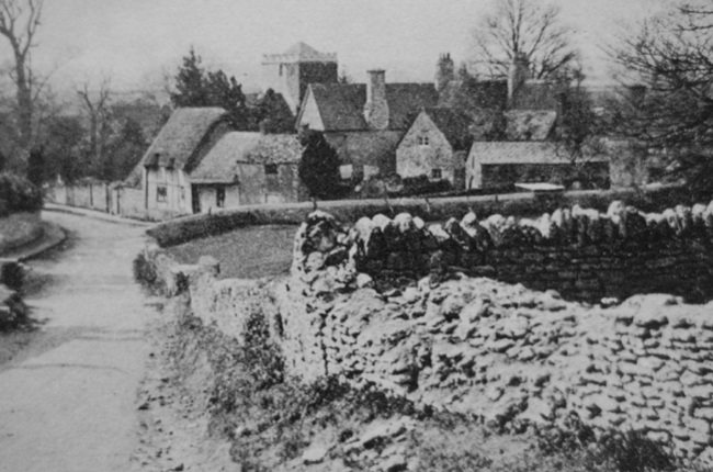
Church Road - A view of Robert Hunt's old forge, centre right, with the Vicarage of 1866 in the rear.
The wall in the foreground is that belonging to the school.
The thatched cottage to the left was burnt down in 1936, seriously damaging the "Queen's Head' opposite.
[From a postcard, c.1900]
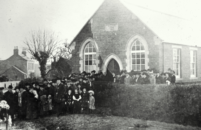
A photograph of the opening ceremony for the Wesleyan Chapel, February 3rd., 1910.
Built at a cost of £400, the Chapel replaced an earlier building a few yards further along Oxford Road, which had opened as a Chapel in 1871.
This 1910 Chapel was to last 99 years as a place of Methodist worship, and is now the Horspath Hub.
Over 50 people attended this ceremony, testament to the strength of Methodism in Horsepath at this time.
[Horspath Scrapbook]
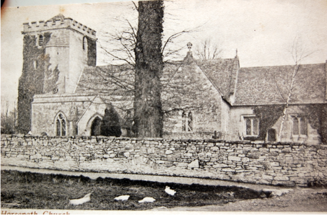
The earliest known photograph of St Giles Church, partially covered in ivy, and the old churchyard wall in front, together with a small part
of the village pond in the foreground. Circa 1880, after the Victorian restorations of the 1840 - 1850 period.
[Old Postcard]
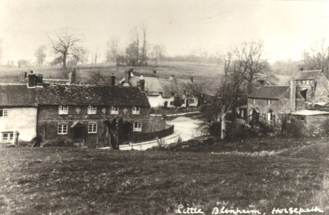
A photograph of "Little Blenheim", a collection of about ten houses forming a detached hamlet north of Horsepath to the north on the road to Horspath
Common and Shotover. All the houses with the exception of the thatched cottages were Victorian labourers' cottages; the thatched cottages probably
17th,c. Blenheim became linked to Horspath by the bungalow expansions of the early 1960s along Blenheim Road and Spring Lane, plus the new road
of Blenheim Way. There are several "Blenheims" in Oxfordshire!
[Horspath Scrapbook]
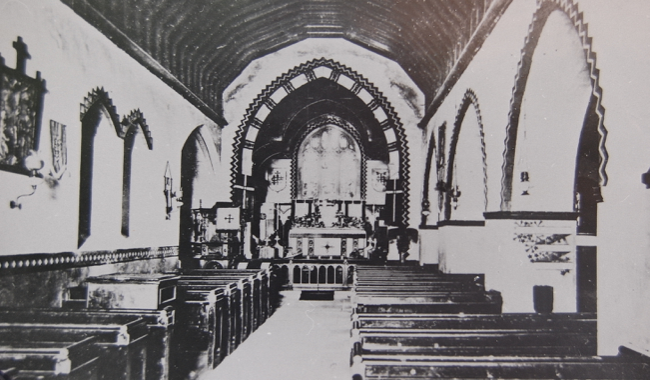
The earliest known view of the interior of St. Giles Church, certainly before 1866, showing the elaborate zigzag borders to the arches and windows,
which were removed later. There is no chancel screen, given in the 1860s by the Revd. Henry Bramley, and on the left can be seen the coke-fired heater
(where the font now stands). The pews were newly installed by a grant of £70 at this time "for use by the poorer inhabitants of the parish".
[Horspath Scrapbook]
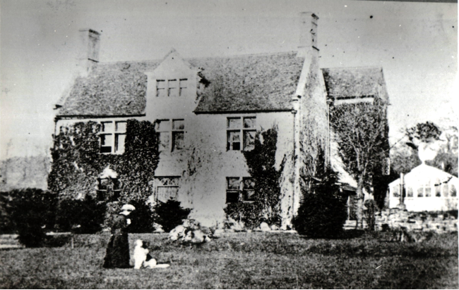
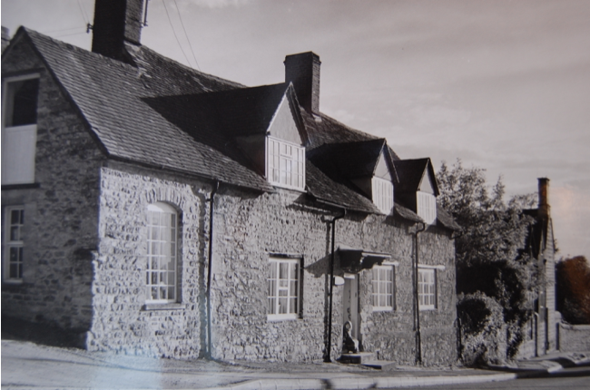
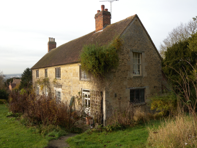
A view of the original Manor House of c. 1513, built by William Bedyll, manorial tenant at the time. This picture shows the property before it was
largely extended in the 1880s to become the building as it stands today.
[Horspath Scrapbook]
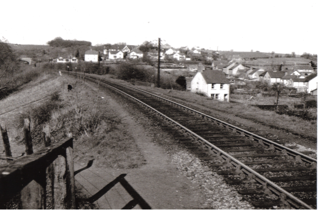
The view from the platform of Horspath Halt in the 1950s, showing the bridge over the Green and Butts Road bridge top left.
The cinder track up to the halt can be seen bottom left, and new housing along Butts Road and up the left-hand side of Gidley Way.
[Cecil Surman album]
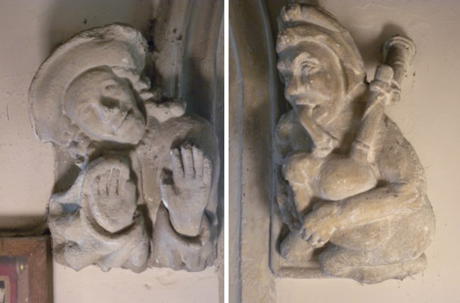
The two strange medieval label stops at the base of the tower arch in St. Giles, which, according to the eminent architectural historian,
Nikolaus Pevsner, "have no parallel in the county". Near lifesize, they date from 1400, and tradition has it that they represent
Thomas London (the bagpiper) and his disapproving wife, who donated money for the tower.
Mythologists suggest they represent dwarfs... but who knows?
[Brian Lowe]
The "Chequers" public house facing the Village Green, pictured in the 1970s. A small plaque on the centre gable says "1624", but the present building
is probably later and rests on 17th.c foundations. A Halls of Oxford (Swan Brewery), it later became an Ind Coope, and later Allied Breweries
tenanted pub, but is now a free house, rebranded as "Taste of India". 1950s photographs show the lounge extension on the left as a "lean-to" shed.
It was here that the Horspath members of N.A.L.U. met while planning their threat of strike action in the 1870s.
[Brian Lowe]
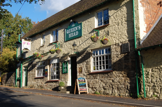
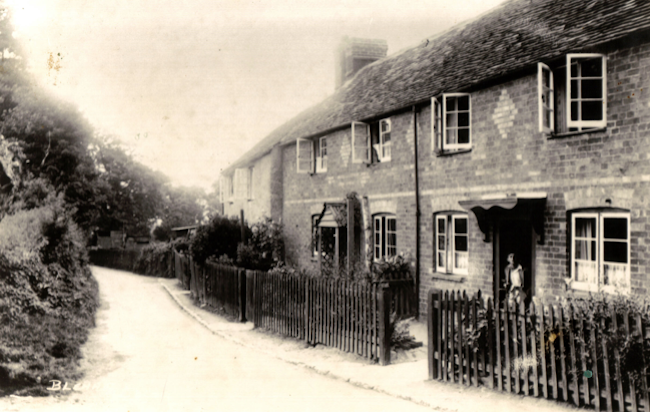
The Queen's Head public house in Church Road, pictured in 2007. Possibly as old as the "Chequers" it has been much extended at the rear,
and similarly was a Hall's of Oxford pub, becoming a free house in 1991. The local Kimber family had a long association with this pub for over 70 years,
relations of William "Merry" Kimber of Headington Quarry Morris Dancing fame.
[Brian Lowe]
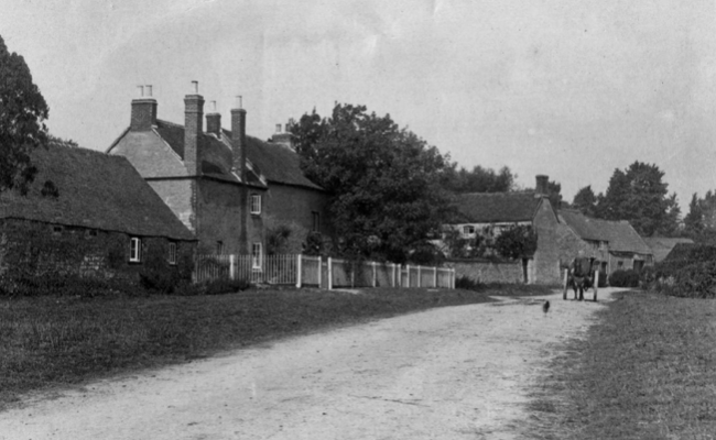
A delightfully rural view of Manor Farm Road, with College Farm to the left, Tudor Cottage beyond, and long-gone houses to the rear.
The farm owes its name to Corpus Christi College, Oxford, who for many years were the landlords - one of four colleges who had ancient
connections with the village. It was the farmer, William Lindsay, who in 1908 bought the parcel of land on which to build the Wesleyan Chapel,
now the Hub by Oxford Road.
[Old postcard]
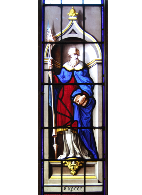
The "Copcot" window in St. Giles Church.
Among St. Giles collection of ancient stained glass is this very rare example of painted glass in an English parish church.
It sits in the north wall of the nave, and has a direct connection with the famous "Boar's Head Carol", traditionally sung in The Queen's College,
Oxford, at Christmas. It depicts one John Copcot (from an 16th.c influential Horsepath family), a student at the College, who while walking on Shotover
was attacked by a wild boar, which he despatched by thrusting a book of Aristotle down its throat.
The boar was then consumed in the college Hall, giving rise to the tradition of the Boar's Head ceremony.
The wild boar was the last to be killed in England, according to the legend.
The window was painted by one of England's most famous glass painters, William Price in around 1740, when he was painting a complete set of windows
for New College... and Magdalen College, Horsepath's patrons, paid £40 for it. (The blue and red cloak is stained glass, the remainder all painted
on glass - a common technique in the 18th.c).
Manor Cottage, just north of the Manor House, in Church Road. One of the village's listed buildings, it dates from the 16th.c,
though has been added to by the addition of the left-hand extension, and by a third gable window, (nearest the camera).
This cottage has a famous connection from the past, as in 1829 it was occupied by the Reverend John Henry Newman and his family,
when he was the vicar of the University Church - and who in 2019 was canonised by the Pope as the first English Saint since the Reformation!
[Brian Lowe]
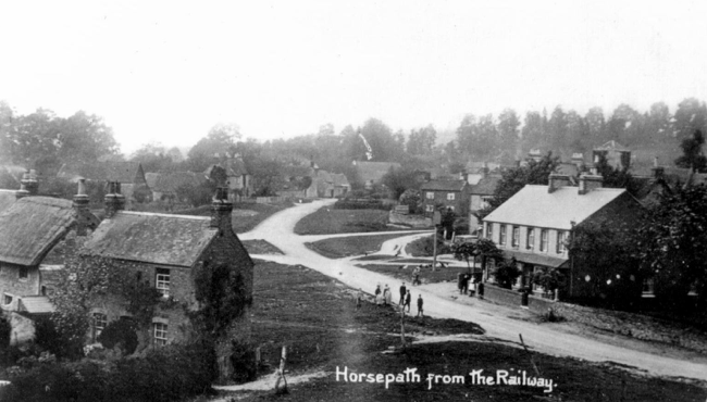
Quite the best views of the village green were taken from the railway embankment! This view shows the road from the bridge up to Manor Farm Road,
around 1900. Church Road goes off to the right. The green has several poles erected in order to dry college washing, which, together with market gardening,
provided valuable business with Oxford and some of the Colleges. There were several carriers in Horsepath at this time; otherwise the village
was predominantly agricultural. At this time there were no means of catching a train to Oxford without first going to Wheatley!
A Halt was erected in 1908 from where this picture was taken, but closed in 1915.
[Old Postcard]
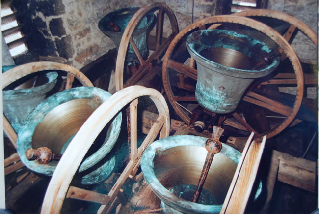
St Giles Bells - The squat and sturdy perpendicular tower contains a ring of six bells, which for generations have been held in high esteem among
bell ringers for their clarity and quality of tone, and their ease of ringing. These bells were apparently well appreciated in earlier times,
for on September 16th., 1733, the famous Oxford diarist, Thomas Hearne, recorded that:
" Mr. Sacheverel, of Denman's Farm in Berkshire near Oxford, who died a few years since, was looked upon as the best judge of bells in England.
He used to say that the Horspath bells, though but five in number and very small, were the prettiest, tunablest bells in England,
and there was nor a fault in one excepting the third, and that so small a fault as it was not to be discerned but by a very good judge".
[Brian Lowe]
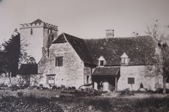
The Malthouse in front of the Church tower. A 17th.c building and listed Grade 2. It originally comprised three cottages in the single building,
which adjoins the churchyard. The 1901 Census lists three families: James Hinton, carter, his wife Elizabeth & six children; Thomas Druce, carpenter,
his wife Mary & three children, and Henry & Ann Surman, who at 68 was still working as a laundress.
[Horspath Scrapbook]
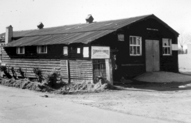
The original Village Hall, which was purchased as First World War army surplus by the Parish Council in 1923, and brought from Wendover.
Opened on October 3rd., 1924, it stood on the left-hand side of the current entrance to the car park.
It served as the hall until 1965, when it was demolished during the planning and preparation of the Village Hall we have today.
[Horspath Scrapbook]
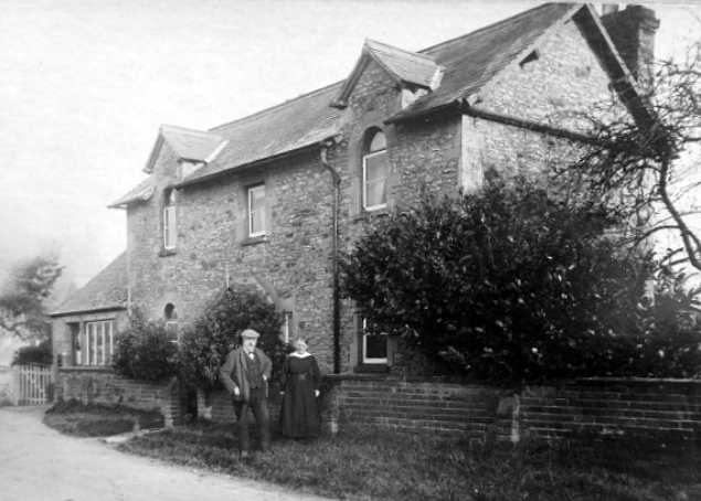
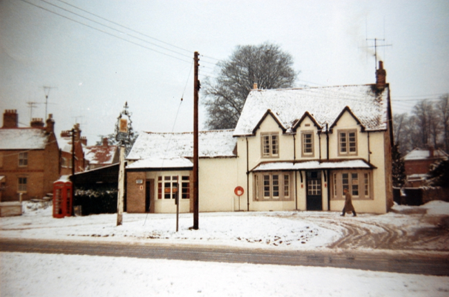
The Second Post Office in Horspath was situated to the side of this house in Oxford Road.
[Horspath Scrapbook]?
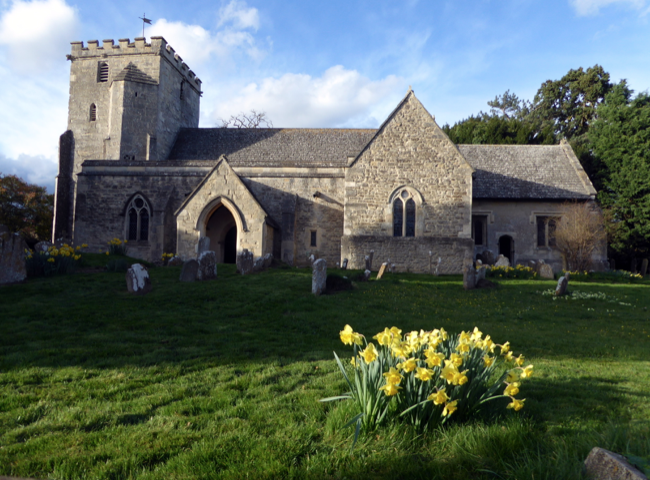
A 2017 view of St. Giles on a late spring evening. The Church is well worth a visit to see its stained & painted glass, Jacobean pulpit and two mysterious lifesized carved figures at the base of the tower arch - and to hear the ring of six bells!! It is usually open in daylight hours. [Brian Lowe]
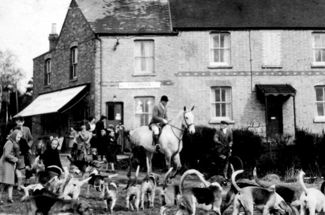
Frederick ("Jiggy"") Coppock's shop on the green, opened in 1953, and still the village store.
This view is of 1955 with the South Oxfordshire Hunt in attendance.
The two girls at left among the hounds are Carol Baker and Josie Shepherd.
Frederick Charles Coppock was known as "Jiggy" due to his work on the jigs at the Cowley works. [Thanks to Lee Dray for information]
[Horspath Scrapbook]
A 1950s view of Butts Lane, as it was then known, looking west towards Church Road. The thatched cottage and adjoining were later demolished
for the new bungalows built in the early 1960s, now Butts Road. They stood between Rectory Farm and Collcutt Close of today.
Behind the cottages stood "Cuffy's Barn", owned by farmer Cuthbert Surman, containing his fearsome bull!
[Cecil Surman album]
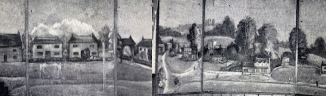
The two paintings which adorned the inside face of the blackout boards in the bay windows of the "Chequers" during the war,
when Freddy Mullins was the landlord, so that the locals could still enjoy the view at night with the lights on!!
The left hand panel depicts the cricket, and the right, the "Chequers" and the Green.
[From a leaflet printed in 1945.]
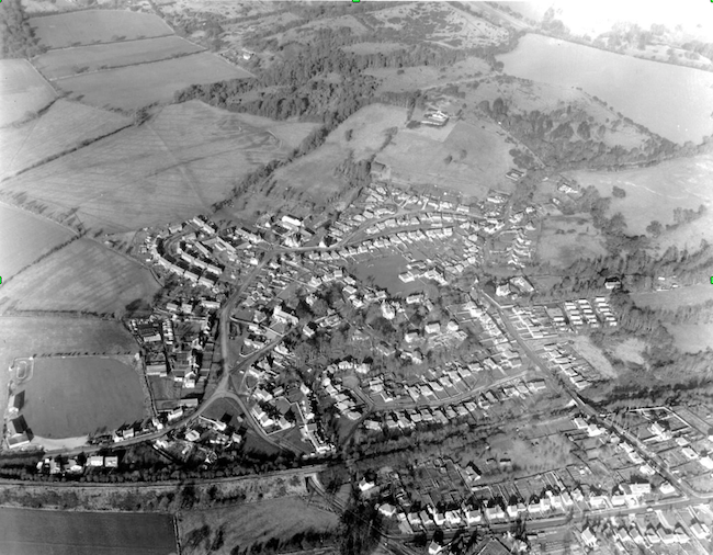
An aerial view of Horspath in 1970 showing well the compact nature of the village grouped round the Church, the dense housing expansion of the 1960s,
and the line of the railway (lower L to R) bisecting the Horspath of today. (Before 1920 this line formed the southern extremity of the village, with
no housing at all in the foreground - Cuddesdon Road & Gidley Way at the bottom). The Village Green is left centre, the Church centre, and Manor Farm
centre top. The previous hamlet of Blenheim is at top right on the slopes of Shotover.
[Brian Lowe, 1970]
An intimate "between the wars" photograph of Victorian labourers' cottages in the then separate hamlet of Blenheim, to the north of Horspath.
There were seven of these cottages originally, all bearing the builder's distinct diamond pattern between the upper windows; two have been demolished
(including the far cottage seen here), and the remaining ones substantially added to. The road leading away is now Blenheim Road, now linked to Horspath
by 1960s bungalow expansion, running to the Manor and the School.
[Horspath Scrapbook]
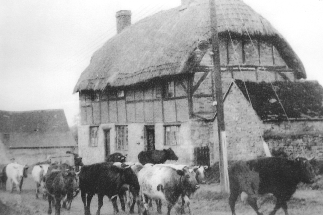
Another period photograph showing cattle heading towards Manor Farm, pre WW2. The farm was always a mix of arable and cattle; even some of the cowsheds
are grade 2* listed buildings! The cottage behind is now 31 Manor Farm Road, but substantially rebuilt and reroofed after yet another Horspath thatch
fire before the war.
[Horspath Scrapbook]
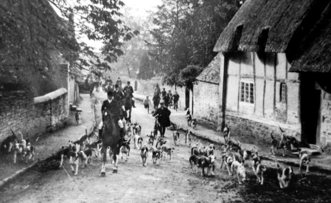
Another 1930s piece of nostalgia: the South Oxon Hunt trots up Church Road, with the "Queen's Head" to the left, and a cottage which was near to the old
forge on the right. This was demolished after a serious fire in the mid-1930s, which also took the thatched roof off the pub! The small stone "lean-to"
attached to the cottage on the right still exists today as an annexe to the Vicarage, whose entrance is just beyond.
[Horspath Scrapbook]
A 1950s view from the railway bridge looking up Gidley Hill, about halfway through its steady accretion of houses, which today line both sides of the road.
Building began here after World War One on the left hand side; before that date this scene would have been fields looking across to the site of
"Upper Horspath", the lost mediaeval village on the skyline at top right.
[Brian Lowe collection]
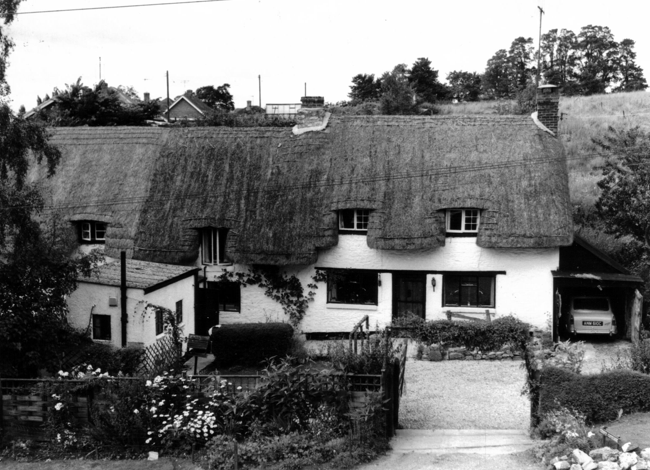
"Ford's Cottage", opposite Manor Farm, and which forms part of a cluster of listed buildings in this corner of Horspath. A Grade II listed building,
timber framed and limestone rubble with plaster infill, and of the only two remaining thatched cottages in the village today. This photograph was taken
in the 1950s before a second first floor window was added and rethatching undertaken.
[Horspath Scrapbook]
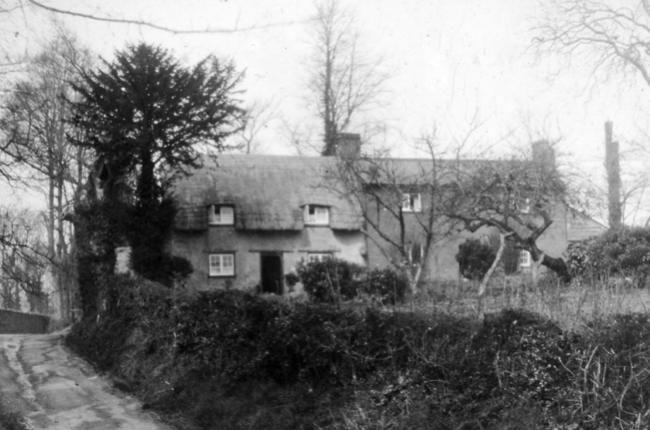
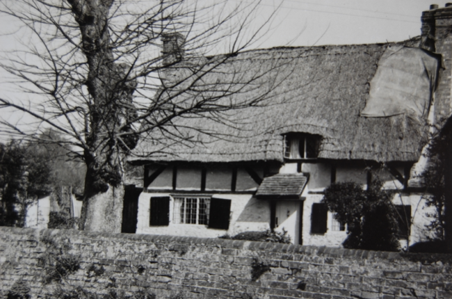
"Croft Cottage", the only other thatched building in the village, in the former hamlet of Blenheim. This 1968 view gives evidence in the thatched roof
that there were originally two separate cottages, with a later infill to make three dwellings, and a further extension was added to the rear in the 1990s.
In the 19th.c this would have been the most northerly cottage in the village at the foot of the hill to the Old London Road; today it is a Grade II
listed building, dating from the late 17th.c.
[Brian Lowe]
One of the dozen or so Horspath farmhouses at one time, this is "Prospect Farm", a mid-18th.c Grade II listed building on the slope to Shotover,
north-east of Horspath. The 1911 Census tells us that it was occupied by David Harris, farmer, with his wife Dorcas and their eight children, the three
oldest all working on the farm. Part of the property was given over to a mobile home park in the 1950s.
[?]
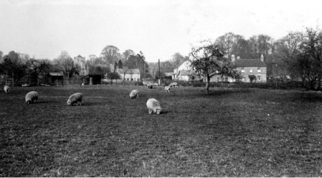
A late 1930s view of the Village Green, occupied by grazing sheep. The Church is at centre left, Church Road in the centre, and what was later to become
the village shop to the right-hand side. Postwar housing was to cover the land in the foreground... and not a vehicle in sight!
[?]